")
Natural Hazard and Risk Methodology


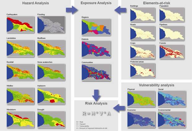
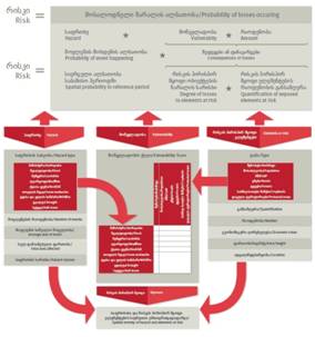 There are three important components in risk analysis: 1) hazards; 2) vulnerability; and 3) elements-at-risk. They are characterized by both spatial and non-spatial attributes. Hazards are characterized by their temporal probability and intensity, derived from frequency-magnitude analysis. The hazard component in the equation actually refers to the probability of occurrence of a hazardous phenomenon within a specified period of time (a reference period). In the analysis we have taken into account 10 different hazard types: earthquakes, floods, landslides, mudflows, rockfall, snow avalanches, wildfire, drought, windstorm and hailstorm. For each of these hazard types a usceptibility maps was generated, classified into three classes (high, moderate and low). The historical information on past events was used to estimate the number of events that are likely to happen in a reference period of 50 years, and the size of individual events. The spatial probability was then calculated by dividing the area of the expected events by the total area of each hazard class.
Vulnerability and exposure was estimated for the following types of elements at risk: buildings, population, Gross domestic product (GDP), roads, forests, crops and natural protected areas. For each combination of hazard type and element at risk the overlapping areas were calculated with a GIS, resulting in the exposure information. Social, physical, environmental and economic vulnerability was expressed using a qualitative spatial mult-criteria evaluation technique. Vulnerability values were estimated for each combination of a hazard class (high, moderate and low) for each of the 10 hazard types and the elements at risk, and presented in a matrix. These were then used in the estimation of the final risk maps,
More on:
Hazard assessment
Exposure analysis
Vulnerability assessment
Risk Assessment